A Brief History of the Early Chesaning Area
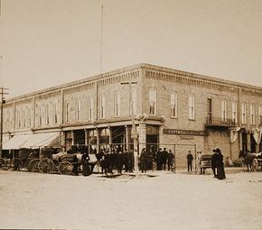
In the year of 1835, by the authority of the territorial legislature, the county of Saginaw was organized. Around 1847 the area of Big Rock was set off as a township and when the township was organized. The first township elections, held in 1847, are considered to be the official birthday of the community.
It was congressional district 9 north, ranges 1,2,3 and 4 east. In 1853 the township name was changed to Chesaning, the Indian name for “Big Rock”, thus bringing it back to its original name. The township remained as large as this until 1856 when the board of supervisors set off ranges 1 and 2 and called it Brady Township; and in 1857 they set off range 4 as Maple Grove Township. This left range 3 as Chesaning township and that is the way it is today, just about six square miles.
Chesaning is a small agricultural community in the southern extent of the Saginaw Valley, which sets to the south and west of the Saginaw Bay, Michigan. The town exists along the southernmost central portion of Saginaw County, halved east-west by the Shiawassee River. The Shiawassee is one of the few rivers in Michigan that run south to north, and certainly the longest to do so. The banks of the river are very high through Chesaning, reaching 15 to 40 feet in height. Traversing the surrounding area are many, almost parallel streams east and west of the Shiawassee River. Seasonal flooding, especially during the spring, made canoe the only method of transportation for long periods of time (Leeson and Clarke, 188 l ). The areas around these streams traditionally became occupied during the winters by local Ojibway and Ottawa, when the larger groups split off into three-family-groups (Ireland, 1966).
Chesaning lies in the heart of the Great Lakes within the former proglacial Lake Saginaw. The fertile lake plain soils are gravelly, sandy loams, mottled with patches of clayey loam (Leeson and Clarke, 1881). The most recent glaciers left the region ten thousand years ago, though several testaments to their legacy remain behind. Saginaw County is an especially flat, topographically monotonous part of Michigan. It is also the only county in the state to have no naturally-formed lakes. Therefore, any geological deposits of significant character or size are very recognizable. A couple of these had some ritual significance among peoples inhabiting this part of Michigan. The Big Rock was one of these; a ceremonial meeting place of Ojibway and Ottawa peoples.
Visit The Chesaning Area Historical Society Website for more information on our rich history.